February 22, 2011

Columbia Hills, November 17, 2011

This particular trip, my hiking partner and I drove East as far as practical from Portland to avoid a rainstorm.   We ended up at the Colmubia Hills which is partly a Washington State Park and partly a WA DNR preserve.  There are grand hills with big views, and also a terrific Oregon White Oak forest.  I've been there a few times, now.  We started out the day under gray skies and wind.  It got worse from there!

We hiked up to Dalles Mountain summit and took a look around.  High winds, cold, and flat light prevented us from staying and taking photos.  So we hiked around the shoulder of the mountain to a spring on the north side.  Here is remaining fall color:


A gigantic remaining mushroom!


The old oak trees are very pretty, even without their leaves.  At this time of year, many grasses are starting to perk up again, just as the trees' leaves have turned brown and fallen off


Fungi on a downed tree:


After hiking here, we drove over the mountain to the Klickitat River Trail.  I've also visited this area many times.  I'd never noticed it before, but there's a nice colony of rabbitbrush along the trail.  This species is normally associated with the High Desert (which is south of here), and blooms in the fall.  By this time, it had been raining for a while, and we were both wet and tired.  Another good trip.  

Hunchback Ridge, November 10 2011:

Hunchback Ridge rises up above the ZigZag Ranger Station, a few miles west of Mt Hood.  I understand that there are views of Mt Hood from the ridge, but I didn't see any on this trip!  

First off, I walked up a few miles of uneventful switchbacks under glowering skies.  I arrived at an open ridge, which didn't have much in the way of the advertised views, but did have atmosphere, at least!


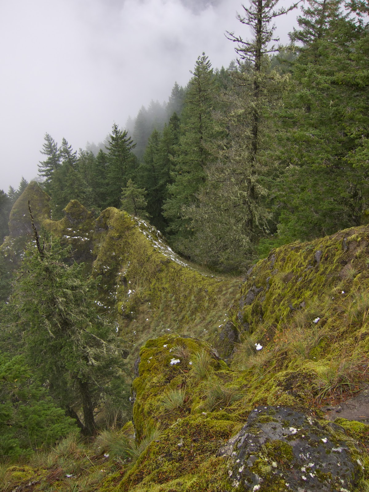
Looking down the rocky spine of the ridge.  The erosion patterns of the local basalt create these fluted, steep ridges that are quite impassable.  Well, I should say that they're passable, but not by any safe means.  Technically, they'd be rough, loose scrambling, with lots of exposure and no way to install protective gear.  Yuck.  


I came to one of the supposed viewpoints and found it practically unreachable, as the field of leaning, loose boulders leading up to it was coated with a fine, slippery sheen of snow.  At this elevation, snow was getting deeper and deeper.  I walked part of the way up, and decided, considering the weather, that slowly and painstakingly crossing the rocking, slippery boulders just wasn't worth it!


I soldiered on up, still planning on being at one particular viewpoint at sunset.  I was getting behind schedule, though, and was losing interest in the cold wet slog uphill through the snow. I did get nice light at a saddle on the ridge, though.


I reached the highpoint of the ridge, and found that the views were limited by my ability to place myself safely.  For this point I was kind of hanging over a bunch of wet roots and poised above a jumbled slope of brush, snow and rocks.  It wasn't so dangerous, but it was mighty inconvenient.


After taking this shot, I ran back down, hoping to get to one of the previous viewpoints in time to see more sunset.  I must have passed the viewpoint earlier, but hadn't seen the spur trail at the time.  I missed it a second time, unfortunately, and spent the next 20 minutes watching the sun light up the sky quite nicely, from inside an obscuring screen of trees and brush.  Oh well.  

Then, after the sun set fully, I ran and walked down the ridge.  It was overgrown in places, steeper than I remembered going up in places, deep with snow in other places.  This actually turned into one of the most difficult of all my hikes.  I even had trouble seeing, as the fog that rolled in over the ridge made my headlamp almost more trouble than worth it.  It was like having the brights on when driving a car through fog- a good bit of the light was reflected back in my eyes.  

When I got back to the open ridge line, I took a few minutes to photograph the moon, rising over the Salmon River.  In the valley below, you can even see the lights of a house.  I think it's part of Welches.  


After that, I walked down part of the way over steadily improving trails before stopping to use my cellphone to wish my grandfather happy birthday.  It was surreal to sit on a log in the dark, halfway up a mountain, cold and wet from snow, fog and sweat, while talking with my grandparents (in Tennessee, about two thousand miles away).  I was glad to have the intense part of the trip over, and appreciative all the same, of how lucky I was to get to have these vital, unpredictable experiences.

Silver Star: Ed's Trail, November 2011

Silver Star is a 4,390 foot mountain near the town of Washougal, in southwest Washington.  It was so named for its radiating ridges' resemblance to a sheriff's star.  I hiked up the popular "Ed's Trail" route back in the fall, on one of those late fall days when the weather makes you think summer might just last all year.  Just another one of the seductive qualities of the Northwest.  

There were mostly clear skies as I walked bare ridges up to the summit.  This mountain complex (really, it's a small mountain range) was burned over viciously in a series of fires called the Yacolt Burn.  The fire was so devastating, and the subsequent replanting so ineffectual that the main high ridges remain mostly bare.  The ecological loss is stunning, and so is the scenic gain!  This is one of the very few close-to-Portland hikes that's not mostly a forest walk.


The trail passes under a basalt rock arch.  Delicate Arch it ain't, but it does sure look fragile.


More clear skies.


I reached the summit quite a while before sunset, and planned on hanging around and exploring the summit ridges till then.


Meanwhile, several other hikers and their dogs (ubiquitous up here) explored the summit with me.


Clouds rolled in from the west, complicating my plans for a sunset photo.  


On the other hand, the clouds refracted sunlight, creating an optical effect referred to as a "glory," or more colorfully, as the "spectre of the Brocken."  Apparently there's a mountain in Germany where the prevailing weather conditions create this phenomenon quite regularly and the mountain people referred to it as a ghost.  I'd never seen one before, so I was quite happy to see it!  I've since seen one of these from an airplane.  The shadow inside the glory is yours truly.


There are also native vision quest pits at the summit.  In the background is Bluff Mountain.


More vision quest pits.


As the sun's last rays warmed up, I walked back over the other side of the summit, hoping to catch so nice colors before clouds rolled in and obscured all the direct light.


I caught this shot quickly as the sun set behind clouds.  Then I noticed a little more light further down the mountain. 


I started running downhill.


By the time I got into the light I was a little too frazzled to compose any shots with real interest.   But here's a jeep road that they drove up and down while trying to reforest the mountain.


Sunset over Portland.


This somewhat alpine landscape is the most interesting thing this close to Portland, and I've found it immensely satisfying to visit, each time.  It's our little corner of the Cascades that reminds me of the Rockies, which I liked very much when I spent a summer in Colorado.  I love the forest, and love trees.  But they constrain the views.


Thanks for reading!