These trails are the best way to see the scenery of the mountains up close. Rather than long approach hikes up steep and heavily forested ridges to timberline viewpoints and scenic vistas, the loop trails climb up and down the sides of the ridges, mostly staying in the open country. One should not, however, think of the trails as basically flat. Instead they are often roller coasters of elevation gain and loss, as the steep ridge sides are sometimes too unstable for a trail. More on that later!
In my two night trip I took about 500 photos. The scenic beauty was continuous and overwhelming. So it's taken me a while to get through the photos. Starting a second job didn't help! I figured it would take too long to whittle down the photos to my best examples, and there is so much to tell about the trip, I've gone heavy on the volume of photos, and I'll just have really long posts. . .
First, I walked up the heavily traveled Ptarmigan Trail, which leads up the southernmost ridge of the mountain to the Loowit Trail. Past the Loowit Trail, the Ptarmigan Trail peters out and heads up Monitor Ridge to the crater rim. I did that climb last summer. It was a great view at the top, but I really didn't like being on the trail with so many other people. In contrast to the 100 or so people I saw on Monitor Ridge on one day last summer, on the Loowit I saw 5 people over the course of three days (one party of three and two other solo hikers). I saw no one after 9 a.m. on day two. Sweet.


Walking this section was difficult. Instead of a trail, one walks over boulders roughly the size of large dogs. This is all an old lava flow (not a flow from the 1980 eruption).

I walked into and out of the first washout of the trip. This turns out to be a tiny one, though it looked impressive when I came to it. They got larger as I walked counter clockwise around the mountain.

I didn't pass any water for the first 3 hours or so of walking. I usually drink a liter every couple of hours, so I was thirsty by the time I came to this chocolate milk colored stream. I wasn't thirsty enough to drink this, though. A lot of the streams run only during the day, when solar heat warms up the glaciers buried under ash and rocks on the crater rim. And other streams run consistently, but pick up too much sediment (pumice) to be palatable. By day two, I could not afford to be picky, and would have to drink water like this. It's like drinking liquid rocks. It's not organic, so it's not disgusting, but it's also just not fun to drink.

Along the way, I came to Dyer Meadows. You can see elk prints in the trail. The mountain is now home to so many elk that there are often more elk prints in the trails than human footprints, and some areas reek of elk feces.

This southern side of the mountain was largely untouched by the 1980 eruption, and is quite similar to the timberline areas of Mt. Hood. I arrived too late for most wildflowers.

Walking west, I took a small break in the lee of some low growing trees.

Here's a view to the south of Mt Hood, 50 miles away in Oregon.

Field of heather in a small dry gully.

Here's the view inside one of the many washed out creek beds. These things were either cut out by the sudden flow of instantaneously melted glaciers during the 1980 eruption, or have been washed out by Spring floods. I know that some of them are ancient stream beds that filled with lahar (volcanic mudflow), and have subsequently washed out deeper every spring snowmelt due to their extremely unstable composition. They are made of fine dust and rocks of various sizes. There aren't any tree roots or sticky organic material to hold it all together. It's a real hassle for trailbuilders, too. Every washout has a provisional trail more or less clinging to the side of the ravine, many requiring holding on to unstable rocks for secure footing. Quite a mess. And the fine dust got deep into my shoes. With every step I was abrading my toes against pumice. I quickly had dried out and irritated toes. I got blisters in several places on each foot. That almost never happens to me.

Some areas, though, look quite normal, and not as damaged.

Here's a much larger washout. Now imagine that all that grey matter is not much more consolidated than beach sand, and much finer. Quite a hassle to walk down through. Luckily, there's a bit of a bench trail, courtesy of the Forest Service.

Here's the walking on a more stable path.

The next big obstacle was a truly huge washout that was kind of intimidating. I walked up with a good bit of trepidation. Each crossing was a little nervy, and I couldn't imagine how they'd managed to deal with this one, which was steeper (vertical in places) and about 100 feet deep or so.


I was kind of ticked off by this point, because I had spent half an hour of the best light trying to find my way out of the washout (there was no signage or even any flagging showing the route here) and wandering off in the wrong direction. It was now about 25 minutes from sunset, and I was a mile from my camp, where I'd hoped to take photos before sunset. I bushwacked through lava flows and thin forest back up to the trail, where I sped off, trying to make time.

One last view of the biggest gully yet.

Nearing campsite, on the southwest corner of the mountain.

Meadows near camp.

As the sun set, I looked down toward Oregon.

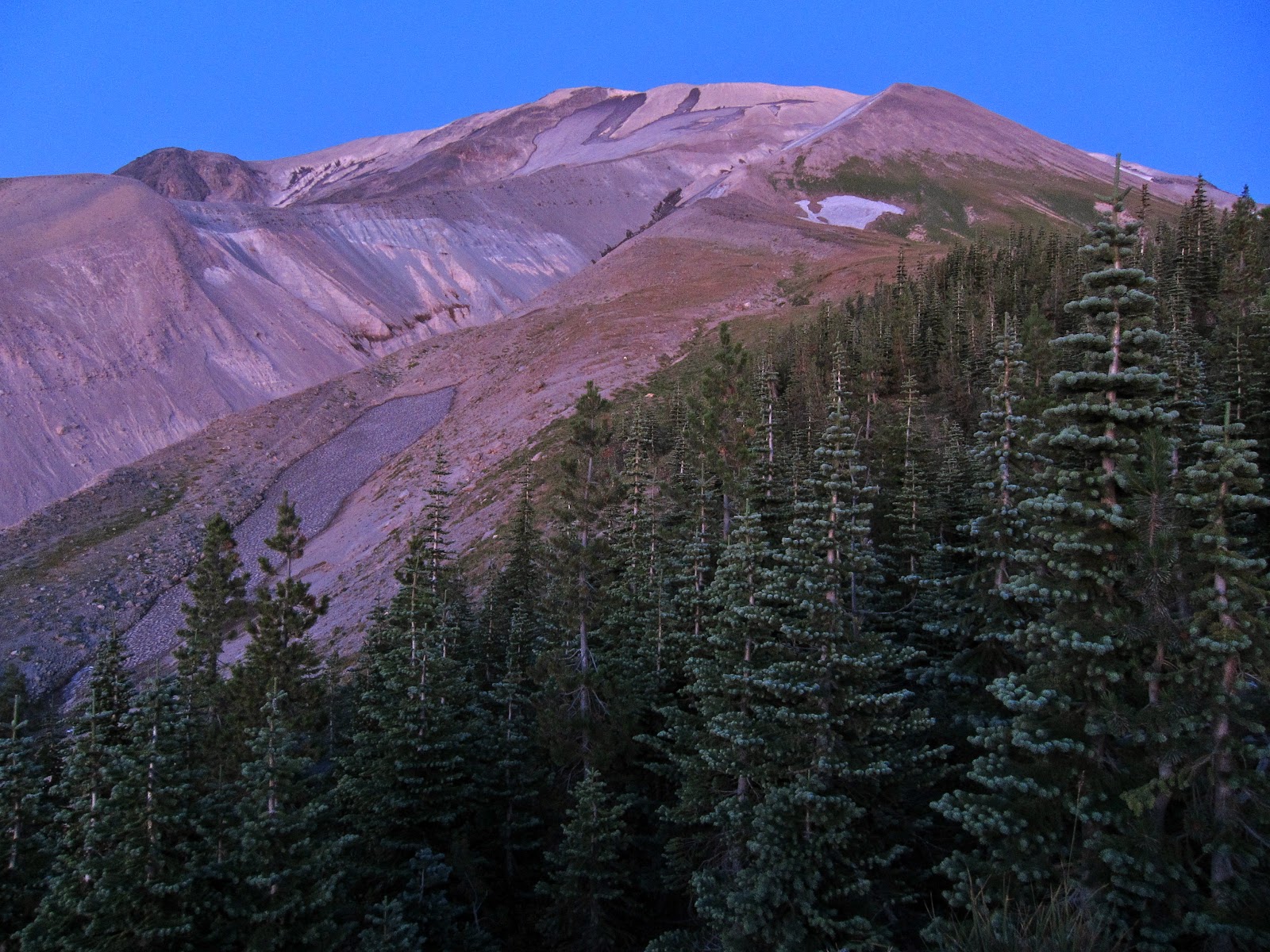
Now, after sunset, I wandered around for about an hour, trying to find a campsite that was sort of unclearly labeled on my map. I couldn't find what I was hoping to be a nice lake with a soft, cedar lined shore, but I did get a nice view of the mountain summit 30 minutes after sunset.
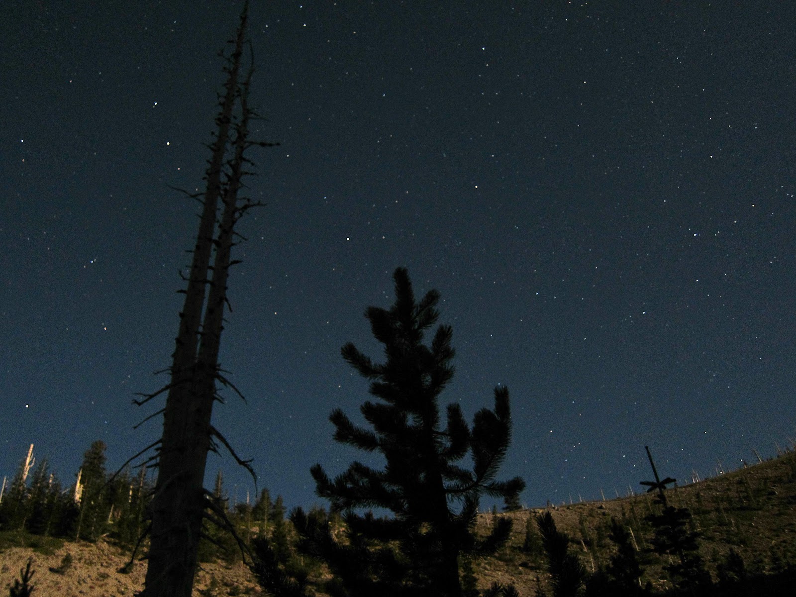
I gave up on the lake (it no longer exists as such- it is now a marsh in a big ditch), and backtracked to the last water I had seen. I set my sleeping bag out and cooked dinner. I also started trying to put my feet back together. I enjoyed a brilliant moonrise, and heard a family of coyotes staking their territory. I'll try and put up a video of that in a separate post.
Next up, day 2.
No comments:
Post a Comment
Please feel free to leave a comment!