I also had to avoid large trees down over the road. In this aspect, my timing was impeccable: traveling after Memorial Day Weekend meant that the many families who travel around with chainsaws (not so uncommon in this state!) had already cleared most of the real obstacles. Here's one:
Coming up the road from Fort Rock, I passed from BLM (formed in 1946 by a merger of the General Land Office and the Grazing Service) into the Deschutes National Forest. The boundary between environments was almost as sudden as the boundary between managing federal agencies:
In ecological study, this is called a ecotone. Ecotones are zones of tension between one ecology and another. Here it is Ponderosa pine woodland and sagebrush-bunchgrass steppelands meeting each other in a pronounced natural edge. To the right, there is just enough moisture to support tree growth. To the left, there's not enough. The government boundaries literally follow this line in this place- BLM gets the steppe, and USFS gets the trees!
On to the cave. Derrick Cave is one of the Northwest's many "lava tube" caves. In short, when there is a volcanic eruption, lava flows downhill just like water. While the lava flows down hill, the top most flowing portion of the stream interacts with colder ambient temperature air, but the lower portion is insulated by the upper portion. The upper portion eventually slows down its flow, and freezes in place, while the lower portion of the flow, still insulated, keeps flowing out downhill. Eventually, the lava stops pumping out of the vent. The last bits of lava flow out the bottom of what is now a tube, and the inside harden and become solid basalt. This will remain a void until the entire thing collapses. In the meantime, parts of the roof collapse gradually, allowing humans entry from above. Here's a skylight, showing the collapsed roof from inside the cave:
I've visited another one of these before, and they're awesome, fascinating, and totally creepy! Every time I visit a cave, I think "this is going to be fun". Then I stick my head in and the complete darkness and utterly foreign smell are overwhelming. I start to have thoughts like, "maybe I shouldn't go in there!" This one had a portion repurposed as a nuclear fallout shelter during the Cold War:
I went down into this portion, and all I could think about were nuclear mutant zombies. The other side has a much larger cavern section. It's like being inside a gigantic natural subway tunnel. Note that there is no light down here, only what my headlamp and camera create.
I also visited a pleasant part of the forest this day. I got to see the Oregon state champion Western Juniper tree, which was a humongous specimen:
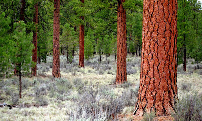
This was a special place- accessible only by very rough roads, and located in a grove of beautiful ponderosas. I'd like to camp here sometime, but only if I can come in by bike instead of car. It's just too rough to be a nice drive. Here are photos of the ponderosas. I've been trying now for a couple of years to take satisfactory photos of old growth, and I'm steadily improving:
From here on out, the roads improved. Here's an odd place where a large power line easement bisects the forest:
I drove back over the Willamette Pass into the Willamette Valley in a steady downpour. This green forest and wetness were a little overwhelming after the aridity of desert country, even in the spring time.
I had a great trip, and I hope you enjoyed my reports!


Nice travelogue! I have been to Derrick twice, but I don't remember the shelter doorway you photographed. Where is it? I thought I remembered that Skeleton Cave was used as a fallout shelter. Have you been there?
ReplyDeleteWe tried to get to Derrick Cave today, but decided that the minivan wasn't going to make it over that road especially when I had no guarantee of actually finding the cave at the other end since there were no signs. I wonder what the deal is with the main road going through that private ranch. Anyway, I know of some other caves that are much easier to get to despite the Forest Service doing it's best to discourage visitors (mostly to protect hibernating bats between the months of November through April).
ReplyDeleteThanks for the pictures.
You have a road to drive on free of charge in your low-slung car so you don't have to hike, then complain about the Forest Service not maintaining it. That's a forest road, not a public highway for urban commuting. You should re-think your attitude a bit.
ReplyDelete